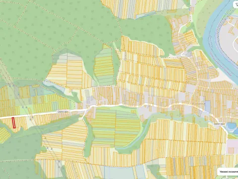
Продаж земельної ділянки площею 0,25 га кадастровий номер 2625881801:02:002:0678, цільове призначення земельної ділянки: для будівництва і обслуговування житлового будинку, господарських будівель і споруд (присадибна ділянка), знаходиться за адресою: Івано-Франківська обл., Тисменицький р., с. Козина, урочище "Чотири дуби", реєстраційний номер об’єкта нерухомого майна: 1513810726258
No sign-up: the bot will message you when the price or dates change, documents or the auction result appear. Or track with an account →
Terms
- Starting price
- UAH 185,570 excl. VAT
- Guarantee deposit
- UAH 55,671
- Bid step
- UAH 1,855.70
- Area
- 0.25 ha
- Cadastral number
- 2625881801:02:002:0678
- Designated use
- Для будівництва і обслуговування житлового будинку, господарських будівель і споруд (присадибна ділянка)
- Location
- Івано-Франківська, КОЗИНА
- Organizer's marketplace
- sales.tsbgalcontract.org.ua
- Sale attempt
- 4
Price compared with similar lots
For comparison: 1,127 lots of type “Seized land” in Ivano-Frankivsk Oblast over the last 12 months. This lot starts at UAH 742,280 per ha — more expensive than 93% of such lots. Half of them are cheaper than UAH 23,388 per ha; the middle 50% range from UAH 4,149 per ha to UAH 32,224 per ha.
How such auctions end: of 141 finished, 21% found a winner and 79% were unsuccessful. Where there was a winner, the price usually rose 1.1× over the starting price.
Calculated by LotRadar from Prozorro.Sale data (median, condition of the asset not considered) — a guide, not a valuation.
Previous auctions of this asset
If a lot is not sold, it is offered again — often cheaper.
- LAE001-UA-20261007-58362 Unsuccessful UAH 225,335 · 16.11.2026
- LAE001-UA-20260828-01150 Unsuccessful UAH 265,100 · 07.10.2026
- LAE001-UA-20260721-21365 Unsuccessful UAH 265,100 · 28.08.2026
What changed
- Status: Terms editing → Accepting bids
- Lot published
Similar open lots
- Земельні торги з реалізації земельної ділянки кадастровий номер №2621210300:04:001:0038 площею 0.3… · UAH 180,600 · 0.3873 ha · НАСЕЛЕНІ ПУНКТИ, ПІДПОРЯДКОВАНІ БУРШТИНСЬКІЙ МІСЬКРАДІ
- Реалізація земельної ділянки площею: 1.1636 га, кадастровий номер земельної ділянки 2623282200:02:… · UAH 176,500 · 1.1636 ha · Богородичин
- ЗЕМЕЛЬНА ДІЛЯНКА. кадастровий номер 2623282200:02:004:0051, що знаходиться за адресою: Івано-Франк… · UAH 198,600 · 0.6624 ha · Жукотинська/с.жукотин
- Земельна ділянка, цільове призначення: для ведення товарного сільськогосподарського виробництва, п… · UAH 200,458.56 · 1.42 ha · ГАЛИЧ
- Продаж земельної ділянки площею 0.35 га кадастровий номер 2624485001:01:002:0384, цільове призначе… · UAH 205,660 · 0.35 ha · ПОМОНЯТА